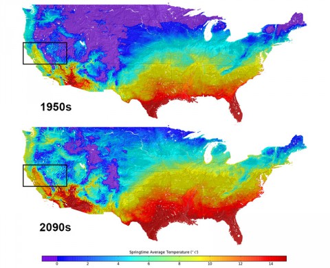
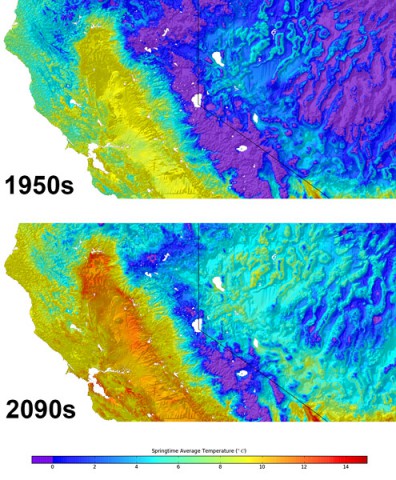
 Moffett Field, CA – Global models of the climate system are now the foundation for many important climate studies, but they typically show climate changes at very large geographic scales on the order of 100 to 250 kilometers. Some data sets have scaled that down to about 10 kilometers, but even these make it difficult to analyze climate change impacts on a local or regional scale.
Using previously published large-scale climate model projections, a team of scientists from NASA, the Climate Analytics Group, Palo Alto, CA, a non-profit that provides climate data services, and California State University, Monterey Bay, has released monthly climate projections for the coterminous United States at a scale of one half mile (800 meters), or approximately the size of a neighborhood.

These climate projections provide a view of future U.S. temperature and precipitation patterns based on four different greenhouse gas emissions scenarios, spanning the period from 1950 to 2099. The new downscaled climate projections were statistically derived from the results of the latest climate scenarios produced by an ensemble of global climate models for the Inter-Governmental Panel on Climate Change 5th Assessment Report (IPCC AR5) and historical surface observations.
“The NEX-DCP30 dataset provides a higher resolution that will be of great reference to the decision-making of natural resource managers, urban planners and the climate change science community,” said Ramakrishna Nemani, senior Earth science researcher at Ames, and a co-author on the study. Details and availability of the new dataset were published in Eos, Transactions American Geophysical Union on September 10th.
 These high-resolution climate scenarios, derived from the best physical models of the climate system available, provide a projection of future climate conditions given certain greenhouse gas emissions scenarios, and account for the effects of local topography on temperature and precipitation patterns.
They also may make it easier for resource managers to quantify anticipated climate change impacts on a wide range of conditions and resources important to local communities, such as water supplies and winter snow packs, public health and the spread of insect-borne diseases, flood risk and potential impacts to critical urban infrastructure, wildfire frequency and severity, agricultural production, and wildlife and biodiversity.
These scenarios can help climate scientists, hydrologists, land and natural resource managers, city planners, engineers and others understand the effects of future climate conditions.
“Our center will use the new climate datasets for the ecological response modeling being done at the center,” said Jeffrey Morisette, director of the North Central Climate Science Center, Denver, CO. “Having access to a rigorous, consistent, and well documented set of high-resolution climate projections will help ensure our analysis and results are coordinated with the IPCC fifth assessment report.”
The high-resolution climate datasets can also help managers at national parks and other protected areas anticipate climate impacts on vulnerable ecosystems in parks across the U.S.
“Climate changes threaten the integrity of parks throughout the National Parks system, and park mangers desperately need data at management-relevant scales to inform decisions,” said John Gross and William Monahan, ecologists with the National Park Service who are leading studies of climate change in our national parks. “These high-resolution assessments are the basis for implementing effective climate adaptation, at management-relevant scales.”
Since information is available at the scale of individual neighborhoods, it also may be of interest to the general public and others seeking to understand future climate conditions for their community.
“We are using the 800-meter downscaled datasets for conservation planning and resource management in the San Francisco Bay Area,” said Stuart Weiss, a researcher at the Terrestrial Biodiversity Climate Change Collaborative in the San Francisco Bay Area. “They provide an indispensable, if necessarily hazy, crystal ball into hydrological and ecological responses through the 21st century. It will be a very useful tool for climate change planning and adaptation that will be exported to the remainder of California and eventually the western United States.”
Production of this dataset required hundreds of thousands of supercomputing hours and very large volumes of data. Previously, it would have taken more than a year to complete.
“The NEX resources are what made this work possible,” says Dr. Bridget Thrasher, a researcher at Climate Analytics Group. “Access to the NAS has proved to be an invaluable asset to my work with climate change projections.”
Future work will expand on current efforts to make the dataset easily accessible to all interested users.
The dataset is currently available via the NASA Center for Climate Simulation at https://portal.nccs.nasa.gov/portal_home/published/NEX.html
To view the dataset, visit the NASA Center for Climate Simulation: https://portal.nccs.nasa.gov/portal_home/published/NEX.html
For more information about the NASA Earth Exchange, visit: https://nex.nasa.gov/nex/
For more information about NASA, visit: http://www.nasa.gov
Written by Ruth Dasso Marlaire
Public Affairs Office
NASA Ames Research Center, Moffett Field, CA


