Written by Alan Buis
NASA’s Jet Propulsion Laboratory
 Pasadena, CA – On August 16th, 2016, at around 10:30am, a brush fire ignited in the Cajon Pass east of Los Angeles, just to the west of Interstate 15. Within a matter of hours, extreme temperatures, high winds and low humidity allowed the fire to spread rapidly, burning through brush left tinder-dry by years of drought.
By August 17th, the fire had expanded dramatically, and firefighters continue to battle to save homes and evacuate residents.

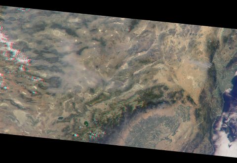
The oblique view angle makes the smoke more apparent than it would be in a more conventional vertical view.
The Los Angeles metropolitan area is the large gray area on the coast in the center of the image. Three plumes from the Blue Cut Fire are clearly visible in the mountains to the north.
This oblique view also shows an enormous cloud of smoke spreading northeastward over a significant portion of eastern California and Nevada. This smoke probably originated from the fire as it consumed almost 20,000 acres on the evening of August 16th and traveled north overnight.
Also visible from this oblique view is considerable haziness filling California’s Central Valley, to the northwest of the Blue Cut Fire. This haziness may be due to smoke from several other fires burning in California, including the Soberanes Fire near Monterey; the Clayton Fire north of San Francisco; the Chimney Fire; and the Cedar Fire, which is visible in the image in the southern Sierra Nevada.
MISR was built and is managed by NASA’s Jet Propulsion Laboratory, Pasadena, California, for NASA’s Science Mission Directorate, Washington. The Terra spacecraft is managed by NASA’s Goddard Space Flight Center, Greenbelt, Maryland. The MISR data were obtained from the NASA Langley Research Center Atmospheric Science Data Center, Hampton, Virginia. JPL is a division of Caltech in Pasadena.


