Written by Rob Gutro
NASA’s Goddard Space Flight Center
 Greenbelt, MD – NASA’s Aqua satellite and NASA-NOAA’s Suomi NPP satellite analyzed the temperatures in Hurricane Nate’s cloud tops and determined that the most powerful thunderstorms and heaviest rain areas were around the center of the tropical cyclone after it made landfall near the mouth of the Mississippi River.
At 8:00pm EDT/7:00pm CDT on October 7th, 2017 Hurricane Nate’s eye was at the mouth of the Mississippi River. National Weather Service radar data and surface observations indicated that Hurricane Nate made landfall near Biloxi, Mississippi, around 12:30am CDT/1:30am EDT on October 8th, with maximum winds of 85 mph (140 kph).

At 2:00am EDT/1:00am CDT, the eye of Hurricane Nate moved over Keesler Air Force Base where the NOAA Hurricane hunter planes reside.
At that time, Nate had maximum sustained winds near 85 mph (140 kph).
By 6:00am EDT/5:00am CDT, Nate had weakened to a tropical storm with maximum sustained winds near 70 mph (110 kph).
NASA Finding Strongest Storms
Infrared light provides valuable temperature data to forecasters and cloud top temperatures give clues about highest, coldest, strongest storms within a hurricane. NASA’s Aqua satellite and NASA-NOAA’s Suomi NPP satellite provided that data and showed strongest storms circled Hurricane Nate’s center.

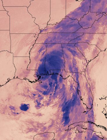
On October 8th at 3:12am EDT (0712 UTC), the VIIRS instrument aboard NASA-NOAA’s Suomi NPP satellite captured this thermal image of Hurricane Nate’s cloud top temperatures just after landfall near Biloxi, Mississippi.
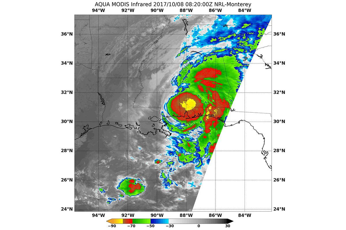
October 8th at 4:20am EDT (0820 UTC) the Moderate Resolution Imaging Spectroradiometer or MODIS instrument aboard NASA’s Aqua satellite analyzed Nate’s cloud top temperatures in infrared light. MODIS found cloud top temperatures of strong thunderstorms circled Nate’s center.
Temperatures in those areas were as cold as or colder than minus 80 degrees Fahrenheit (minus 62.2 Celsius). Some of those strong fragmented bands of thunderstorms were over western Cuba. Cloud top temperatures that cold indicate strong storms that have the capability to create heavy rain.
Heavy Rainfall Forecasts
The National Hurricane Center forecast noted that Nate is expected to produce the following rain accumulations through Monday: East of the Mississippi River from the central Gulf Coast into the Deep South, eastern Tennessee Valley, and southern Appalachians: 3 to 6 inches, maximum 10 inches. Across the Ohio Valley into the central Appalachians: 2 to 5 inches, maximum 7 inches.
Watches and Warnings
On Sunday, October 8th, a Storm Surge Warning is in effect from the Mississippi/Alabama border to the Okaloosa/Walton County Line, Florida. A Tropical Storm Warning is in effect from the * Alabama/Florida border eastward to Indian Pass, Florida.
Status of Tropical Storm Nate on Oct. 8, 2017
At 7:00am CDT/8:00am EDT (1200 UTC), the center of Tropical Storm Nate was located by NOAA Doppler weather radars and surface observations near 32.0 degrees north latitude and 88.0 degrees west longitude.
Nate was moving toward the north-northeast near 23 mph (37 kph). A turn toward the northeast with an increase in forward speed is expected during the next couple of days. Maximum sustained winds have decreased to near 45 mph (75 kph) with higher gusts. The estimated minimum central pressure is 994 millibars.
On the forecast track, Nate’s center will continue to move inland across the Deep South, Tennessee Valley, and central Appalachian Mountains through Monday. Nate is expected to continue to quickly weaken as it moves farther inland. It should degenerate into a remnant low late Monday, October 9th.
For forecast updates and local effects of storm surge, winds, rainfall, flooding and tornado information visit the NHC webpage: www.nhc.noaa.gov


