 Washington, DC – The latest U.S. Drought Monitor, dated August 14th, indicates that some drought-affected areas of the United States have begun to turn the corner with respect to the historic drought of 2012.
During the seven-day period ending August 14th, conterminous U.S. drought coverage fell to 61.8%, down from a July 24th peak of 63.9%. Continental U.S. coverage of extreme to exceptional drought (D3 to D4), the two worst drought categories, dipped to 23.7%, less than one-half of a percentage point below last week’s peak.

However, U.S. exceptional drought (D4) coverage actually rose in the last week, from 4.2 to 6.3%, on the strength of worsening conditions in Colorado, Kansas, Missouri, Nebraska, and Oklahoma. In fact, Missouri leads the nation—according to USDA’s National Agricultural Statistics Service—in very poor to poor ratings for pastures (98% VP to P), corn (84%), and soybeans (75%).
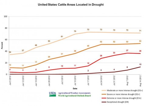
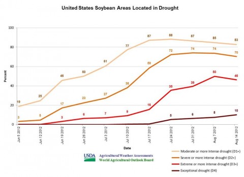
Currently, 85% of the U.S. corn is within an area experiencing drought, along with 83% of the soybeans, 71% of the domestic cattle inventory, and 63% of the hay. The “in-drought” numbers peaked three weeks ago, on July 24th, with 89% of the corn, 88% of the soybeans, 73% of the cattle, and 66% of the hay.

Crops and cattle in extreme to exceptional drought (D3 to D4) peaked a week ago, on August 7. Current D3 to D4 coverage includes 49% of the U.S. corn, 46% of the soybeans, 36% of the cattle, and 30% of the hay. However, D4 coverage rose again, with 9% of the corn, 10% of the soybeans, 11% of the hay, and 13% of the cattle currently experiencing exceptional drought.
Weather Update and Outlook
 An autumn-like cold front currently crossing the Midwest will reach the Northeast on Friday. From the Midwest into the Northeast, rainfall associated with the cold front’s passage will generally total an inch or less, except for a few higher amounts in thunderstorms.
During the weekend, the tail of the cold front will stall across the South. As a result, one- to three-inch rainfall totals can be expected during the next five days from the southern Plains into the Southeast.
In the front’s wake, an extended period of cool, mostly dry weather can be expected across many of the nation’s drought-affected regions, including the northern and central Plains and the Midwest.
In fact, the next opportunity for significant rainfall across the northern and central Plains and the Midwest will not occur until the end of next week, around August 23rd-24th.
Visit www.usda.gov/drought for the latest information regarding USDA’s Drought Disaster response and assistance.


