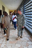
Chief Warrant Officer 2 Angel Mitre, right, the Joint Forces Command – United Assistance liaison officer to the National Ebola Crisis Center, Monrovia, explains to personnel from the Liberian Institute of Statistics – Geo-Information Services how an exchange of geospatial data between the JFC-UA and LISGIS created a more robust, useful product for organizations supporting Operation United Assistance, Oct. 29, 2014. Mitre’s team is assisting, mentor and training the LISGIS, the geospatial arm of the NECC – the government of Liberia’s nerve center for non-governmental organizations. From Left to right: Kayloe R. Frank, LISGIS technician; Cpl. Christopher Byers, geospatial information services mentor for JFC-UA; James Z. Barzon, LISGIS technician; Andy Tugbah, LISGIS technician; and Barry Miller, geospatial intelligence analyst from the National Geospatial-Intelligence Agency.
Home Chief Warrant Officer 2 Angel Mitre, right, the Joint Forces Command – United Assistance liaison officer to the National Ebola Crisis Center, Monrovia, explains to personnel from the Liberian Institute of Statistics – Geo-Information Services how an exchange of geospatial data between the JFC-UA and LISGIS created a more robust, useful product for organizations supporting Operation United Assistance, Oct. 29, 2014. (Sgt. 1st Class Nathan Hoskins) Chief Warrant Officer 2 Angel Mitre, right, the Joint Forces Command – United Assistance liaison officer to the National Ebola Crisis Center, Monrovia, explains to personnel from the Liberian Institute of Statistics – Geo-Information Services how an exchange of geospatial data between the JFC-UA and LISGIS created a more robust, useful product for organizations supporting Operation United Assistance, Oct. 29, 2014. (Sgt. 1st Class Nathan Hoskins)
Chief Warrant Officer 2 Angel Mitre, right, the Joint Forces Command – United Assistance liaison officer to the National Ebola Crisis Center, Monrovia, explains to personnel from the Liberian Institute of Statistics – Geo-Information Services how an exchange of geospatial data between the JFC-UA and LISGIS created a more robust, useful product for organizations supporting Operation United Assistance, Oct. 29, 2014. (Sgt. 1st Class Nathan Hoskins)