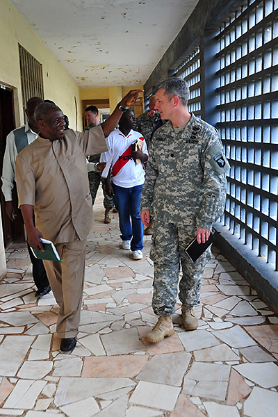
T. Edward Liberty, left, Ph.D., the director general of the Liberian Institute of Statistics – Geo-Information Services, gives a tour of the LISGIS headquarters to Lt. Col. David Conkle, right, the assistant chief of staff of intelligence for JFC-UA, during a meeting Oct. 29, 2014, at the LISGIS headquarters in Monrovia. Conkle oversees a team of geospatial engineers who mentor, train and assist LISGIS personnel who are tasked with supplying maps, statistics and numerous other imagery products and data to all the non-governmental and governmental organizations working the OUA mission. (U.S. Army photo by Sgt. 1st Class Nathan Hoskins, Joint Forces Command – United Assistance Public Affairs/RELEASED)
Home T. Edward Liberty, left, Ph.D., the director general of the Liberian Institute of Statistics – Geo-Information Services, gives a tour of the LISGIS headquarters to Lt. Col. David Conkle, right, the assistant chief of staff of intelligence for JFC-UA, during a meeting Oct. 29, 2014, at the LISGIS headquarters in Monrovia. (Sgt. 1st Class Nathan Hoskins) T. Edward Liberty, left, Ph.D., the director general of the Liberian Institute of Statistics – Geo-Information Services, gives a tour of the LISGIS headquarters to Lt. Col. David Conkle, right, the assistant chief of staff of intelligence for JFC-UA, during a meeting Oct. 29, 2014, at the LISGIS headquarters in Monrovia. (Sgt. 1st Class Nathan Hoskins)
T. Edward Liberty, left, Ph.D., the director general of the Liberian Institute of Statistics – Geo-Information Services, gives a tour of the LISGIS headquarters to Lt. Col. David Conkle, right, the assistant chief of staff of intelligence for JFC-UA, during a meeting Oct. 29, 2014, at the LISGIS headquarters in Monrovia. (Sgt. 1st Class Nathan Hoskins)