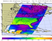
This false-colored infrared NOAA GOES-East satellite image from Feb. 13 at 15:15 UTC (10:15 a.m. EST) shows the blanket of clouds over much of the eastern U.S. (NOAA)
Home This false-colored infrared NOAA GOES-East satellite image from Feb. 13 at 15:15 UTC (10:15 a.m. EST) shows the blanket of clouds over much of the eastern U.S. (NOAA) This false-colored infrared NOAA GOES-East satellite image from Feb. 13 at 15:15 UTC (10:15 a.m. EST) shows the blanket of clouds over much of the eastern U.S. (NOAA)
This false-colored infrared NOAA GOES-East satellite image from Feb. 13 at 15:15 UTC (10:15 a.m. EST) shows the blanket of clouds over much of the eastern U.S. (NOAA)