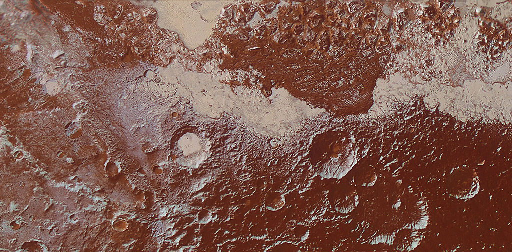
This enhanced color view of Pluto’s surface diversity was created by merging Ralph/Multispectral Visible Imaging Camera (MVIC) color imagery (650 meters or 2,132 feet per pixel) with Long Range Reconnaissance Imager panchromatic imagery (230 meters or 755 feet per pixel). At lower right, ancient, heavily cratered terrain is coated with dark, reddish tholins. At upper right, volatile ices filling the informally named Sputnik Planum have modified the surface, creating a chaos-like array of blocky mountains. Volatile ice also occupies a few nearby deep craters, and in some areas the volatile ice is pocked with arrays of small sublimation pits. (NASA/JHUAPL/SwRI)
Home This enhanced color view of Pluto’s surface diversity was created by merging Ralph/Multispectral Visible Imaging Camera (MVIC) color imagery (650 meters or 2,132 feet per pixel) with Long Range Reconnaissance Imager panchromatic imagery (230 meters or 755 feet per pixel). At lower right, ancient, heavily cratered terrain is coated with dark, reddish tholins. At upper right, volatile ices filling the informally named Sputnik Planum have modified the surface, creating a chaos-like array of blocky mountains. Volatile ice also occupies a few nearby deep craters, and in some areas the volatile ice is pocked with arrays of small sublimation pits. (NASA/JHUAPL/SwRI) This enhanced color view of Pluto's surface diversity was created by merging Ralph/Multispectral Visible Imaging Camera (MVIC) color imagery (650 meters or 2,132 feet per pixel) with Long Range Reconnaissance Imager panchromatic imagery (230 meters or 755 feet per pixel). At lower right, ancient, heavily cratered terrain is coated with dark, reddish tholins. At upper right, volatile ices filling the informally named Sputnik Planum have modified the surface, creating a chaos-like array of blocky mountains. Volatile ice also occupies a few nearby deep craters, and in some areas the volatile ice is pocked with arrays of small sublimation pits. (NASA/JHUAPL/SwRI)
This enhanced color view of Pluto’s surface diversity was created by merging Ralph/Multispectral Visible Imaging Camera (MVIC) color imagery (650 meters or 2,132 feet per pixel) with Long Range Reconnaissance Imager panchromatic imagery (230 meters or 755 feet per pixel). At lower right, ancient, heavily cratered terrain is coated with dark, reddish tholins. At upper right, volatile ices filling the informally named Sputnik Planum have modified the surface, creating a chaos-like array of blocky mountains. Volatile ice also occupies a few nearby deep craters, and in some areas the volatile ice is pocked with arrays of small sublimation pits. (NASA/JHUAPL/SwRI)