Written by Rob Gutro
NASA’s Goddard Space Flight Center
 Greenbelt, MD – At 6:00pm CDT Friday, August 25th, 2017, the National Hurricane Center noted that Harvey had strengthened to a Category 4 Hurricane on the Saffir-Simpson Hurricane Wind Scale. Harvey’s winds had increased to 130 mph (215 kph).
At 7:00pm CDT (7:00pm CDT), the NHC said that the eye of Category 4 Harvey was approaching the coast between Port Aransas and Port O’Connor, Texas and that “catastrophic flooding expected due to heavy rainfall and storm surge.”

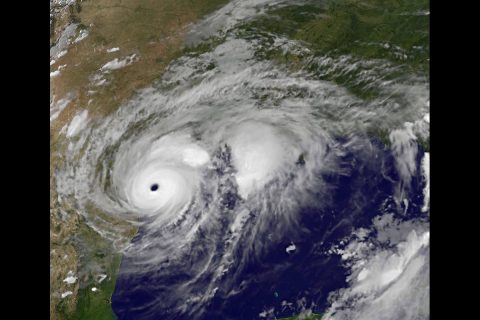
At 7:55pm CDT when Harvey’s large eye was at the coast between Port Aransas and Port O’Connor, NOAA’s GOES East satellite provided an infrared picture of the massive storm. The eye appeared clear in the image created at NASA/NOAA GOES Project at NASA’s Goddard Space Flight Center, Greenbelt, Maryland.
A Storm Surge Warning is in effect for Port Mansfield to High Island Texas, a Hurricane Warning is in effect for Port Mansfield to Sargent, Texas, and a Tropical Storm Warning is in effect from north of Sargent to High Island, Texas.
At 7:00pm CDT (0000 UTC) the National Hurricane Center said the eye of Hurricane Harvey was located by reconnaissance aircraft and NOAA Doppler radar near latitude 27.8 North, longitude 96.8 West.

Harvey is moving toward the northwest near 8 mph (13 km/h), but its forward speed is expected to decrease during the next couple of days. On the forecast track, Harvey will make landfall on the middle Texas coast during the next several hours. Harvey is then likely to meander near or just inland of the middle Texas coast through the weekend.
Reports from an Air Force Reserve Hurricane Hunter aircraft indicate that maximum sustained winds remain near 130 mph (215 km/h) with higher gusts. Harvey is a category 4 hurricane on the Saffir-Simpson Hurricane Wind Scale. Little change in strength is likely before landfall. Weakening is then expected over the weekend while the center moves inland over Texas.
Hurricane-force winds extend outward up to 35 miles (55 km) from the center, and tropical-storm-force winds extend outward up to 140 miles (220 km). A Texas Coastal Ocean Observing Network station at Aransas Pass recently reported sustained winds of 79 mph (128 km/h) and a wind gust of 101 mph (163 km/h).
Following is the NHC’s forecast as of 7:00pm CDT:
Harvey is expected to produce total rain accumulations of 15 to 30 inches and isolated maximum amounts of 40 inches over the middle and upper Texas coast through next Wednesday. During the same time period Harvey is expected to produce total rain accumulations of 5 to 15 inches in far south Texas and the Texas Hill Country over through southwest and central Louisiana. Rainfall of this magnitude will cause catastrophic and life-threatening flooding.
Storm Surge
The combination of a dangerous storm surge and the tide will cause normally dry areas near the coast to be flooded by rising waters moving inland from the shoreline. The water is expected to reach the following heights above ground if the peak surge occurs at the time of high tide…
Port Aransas to Port O’Connor…9 to 13 ft
Elsewhere N Entrance Padre Island Natl Seashore to Sargent…6 to 12 ft
Sargent to Jamaica Beach…5 to 8 ft
Port Mansfield to N Entrance Padre Island Natl Seashore…3 to 5 ft
Jamaica Beach to High Island…2 to 4 ft
Mouth of the Rio Grande to Port Mansfield…1 to 3 ft
High Island to Morgan City…1 to 3 ft
The deepest water will occur along the immediate coast near and to the northeast of the landfall location, where the surge will be accompanied by large and destructive waves. Surge-related flooding depends on the relative timing of the surge and the tidal cycle, and can vary greatly over short distances.
Hurricane conditions are occuring along the coast in the Port Aransas area and should spread over other portions of the hurricane warning area during the next several hours. Tropical storm conditions are occurring in other portions of the hurricane and tropical storm warning areas. Tropical storm conditions are likely to persist along portions of the coast through at least Sunday.
Surf
Swells generated by Harvey are affecting the Texas, Louisiana, and northeast Mexico coasts. These swells are likely to cause life-threatening surf and rip current conditions. Please consult products from your local weather office.
Tornadoes
A few tornadoes are possible through Saturday near the middle and upper Texas coast into far southwestern Louisiana.
NHC’s longer forecast says: Based on the forecast track, Harvey is expected to make landfall along the middle Texas coast tonight. After that, the track models insist that the hurricane will slow down considerably during the next 24 hours, and it is likely to move very little between 36 and 120 hours.
For forecast updates, visit: www.nhc.noaa.gov #HurricaneHarvey


