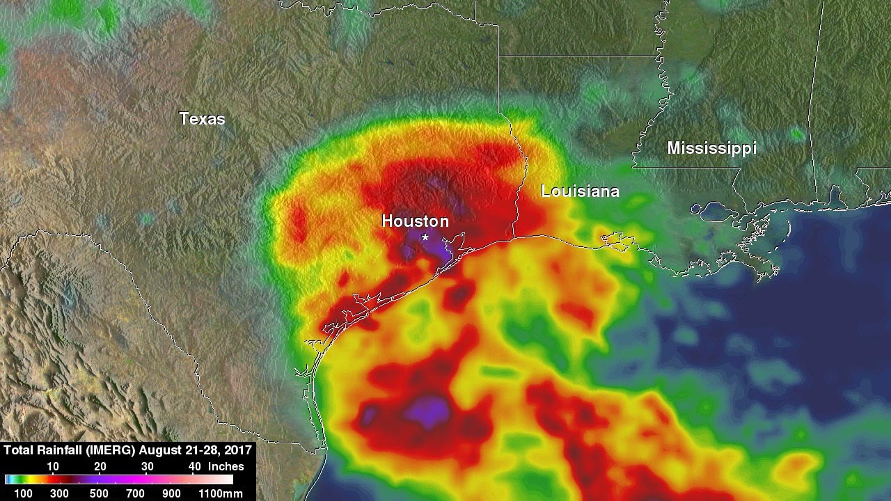
NASA’s IMERG rainfall analysis for Tropical Storm Harvey covers the period from Aug. 21 through Aug. 28, 2017. IMERG shows rainfall totals to 20 inches (purple shading) from the coast near Galveston Bay to in and around the Houston area. At least 10 inches (red shading) are shown to have fallen from western Louisiana all the way to near Corpus Christi on the coast. (NASA/JAXA, Hal Pierce)
Home NASA’s IMERG rainfall analysis for Tropical Storm Harvey covers the period from Aug. 21 through Aug. 28, 2017. IMERG shows rainfall totals to 20 inches (purple shading) from the coast near Galveston Bay to in and around the Houston area. At least 10 inches (red shading) are shown to have fallen from western Louisiana all the way to near Corpus Christi on the coast. (NASA/JAXA, Hal Pierce) NASA's IMERG rainfall analysis for Tropical Storm Harvey covers the period from Aug. 21 through Aug. 28, 2017. IMERG shows rainfall totals to 20 inches (purple shading) from the coast near Galveston Bay to in and around the Houston area. At least 10 inches (red shading) are shown to have fallen from western Louisiana all the way to near Corpus Christi on the coast. (NASA/JAXA, Hal Pierce)
NASA’s IMERG rainfall analysis for Tropical Storm Harvey covers the period from Aug. 21 through Aug. 28, 2017. IMERG shows rainfall totals to 20 inches (purple shading) from the coast near Galveston Bay to in and around the Houston area. At least 10 inches (red shading) are shown to have fallen from western Louisiana all the way to near Corpus Christi on the coast. (NASA/JAXA, Hal Pierce)