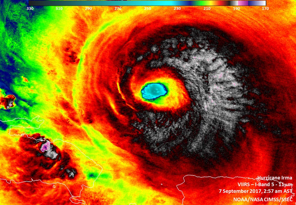
At 2:57 a.m. AST/EDT on Sept. 7, Infrared imagery from Suomi NPP revealed cloud top temperatures as cold as (white) 190 kelvin (minus 83.1 degrees Celsius/minus 117.7 degrees Fahrenheit) from Irma’s northern quadrant, stretching through the eastern side to the south of the eye. (NOAA/NASA/UWM-CIMSS, William Straka III)
Home At 2:57 a.m. AST/EDT on Sept. 7, Infrared imagery from Suomi NPP revealed cloud top temperatures as cold as (white) 190 kelvin (minus 83.1 degrees Celsius/minus 117.7 degrees Fahrenheit) from Irma’s northern quadrant, stretching through the eastern side to the south of the eye. (NOAA/NASA/UWM-CIMSS, William Straka III) At 2:57 a.m. AST/EDT on Sept. 7, Infrared imagery from Suomi NPP revealed cloud top temperatures as cold as (white) 190 kelvin (minus 83.1 degrees Celsius/minus 117.7 degrees Fahrenheit) from Irma's northern quadrant, stretching through the eastern side to the south of the eye. (NOAA/NASA/UWM-CIMSS, William Straka III)
At 2:57 a.m. AST/EDT on Sept. 7, Infrared imagery from Suomi NPP revealed cloud top temperatures as cold as (white) 190 kelvin (minus 83.1 degrees Celsius/minus 117.7 degrees Fahrenheit) from Irma’s northern quadrant, stretching through the eastern side to the south of the eye. (NOAA/NASA/UWM-CIMSS, William Straka III)