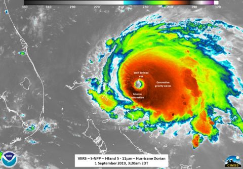
Devastating Category 5 Hurricane Dorian Makes a Direct Hit on Abacos Islands
 Greenbelt, MD – NASA reports that the eye of Category 5 Hurricane Dorian was directly over the Abacos Islands as of the National Hurricane Center’s (NHC) 3:00pm CDT advisory and is now heading towards Grand Bahama Island.
The hurricane is located about 185 miles (295 km) east of West Palm Beach, FL. Maximum sustained winds are 185 mph (295 km/h) with gusts over 200 mph.
Dorian is moving west at 7 mph. The central pressure is 911 Mb which continues to lower meaning the storm continues to intensify. This is the fifth Category 5 hurricane sustained in the last five years.

NASA and NOAA satellites flew over the storm after the NHC’s 1:00am CDT (0600Z) advisory each highlighting unique features within the storm.
At 4:20am CDT (0720 UTC) NASA’s Suomi NPP satellite caught Dorian (above) on the east side of the scan in the Day Night band but due to the angle did not yield as many features due to noise at the edge of the scan, however, the well-defined eye can still be seen along with the tropospheric convective gravity waves flowing away from the storm.
A slower westward motion should continue for the next day or two, followed by a gradual turn toward the northwest. On this track, the core of extremely dangerous Hurricane Dorian will continue to pound Great Abaco today and the move near or over Grand Bahama Island tonight and Monday. The hurricane should move closer to the Florida east coast late Monday through Tuesday night.
Hurricane-force winds extend outward up to 45 miles (75 km) from the center and tropical-storm-force winds extend outward up to 140 miles (220 km). The eye of the hurricane is now 25 nautical miles across.
For continuous coverage visit: https://nhc.noaa.gov


