 Clarksville, TN – On January 22nd, 2020 Johns Hopkins University unveiled a COVID-19 map that tracked confirmed cases of the new coronavirus from all over the world.

The map, which provided updated information for each country, quickly became an important resource for this pandemic, with major media outlets like ABC News, Forbes and The Guardian linking to the map in their stories.
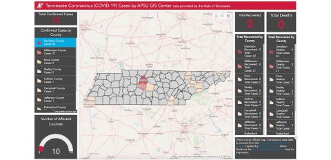
Now, Tennesseans can get this type of information for their home state, thanks to a new map developed by the Austin Peay State University (APSU) Geographic Information Systems (GIS) Center.
The map is available at https://Covid19.apsugis.org.
“After looking at the John Hopkins map, we thought it would be a good way of keeping the local area informed of the number of cases that are being reported here in Tennessee,” Doug Catellier, APSU GIS project manager, said. “The map itself highlights the counties that have reported confirmed cases of the COVID-19 (coronavirus).”
Using the Johns Hopkins map as a template, GIS data analyst Mason Cordell and Austin Peay State University student Bryndon Rhoton developed an online tool that pulls data from the Tennessee Department of Health’s website. That website is updated every day at 2:00pm.
“The overall dashboard is there to show a little more detail of the number of cases that are being reported in each county,” Catellier said. “As the Department of Health updates their website, we may add more data to the overall dashboard just to keep people informed.
For more information on Austin Peay State University’s GIS Center, visit www.apsugis.org


