Written by Rob Gutro
NASA Goddard Space Flight Center
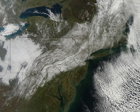
 Greenbelt, MD – A late October snowstorm from a Nor’easter blanketed the eastern U.S. from West Virginia to Maine and broke records the weekend before Halloween Monday. NASA’s Aqua satellite flew over the region on October 30th after the snow was ending in New England and captured the ghostly blanket of white.
A high pressure area located over southeastern Canada was responsible for bringing in cold air and that combined with a low near the North Carolina coast this weekend. The result was an unusual snowstorm from West Virginia to Maine.

When NASA’s Aqua satellite passed over the northeastern U.S. on October 30th, 2011 at 11:30am EDT, the Moderate Resolution Imaging Spectroradiometer (MODIS) instrument captured a detailed image of the ghostly snowfall. The image clearly shows the snow on the ground from West Virginia to Maine along the U.S. East coast. The image was created at NASA’s Goddard Space Flight Center in Greenbelt, MD.
Although the snowfall is over, the damage will haunt New Jersey, Connecticut, western Massachusetts and parts of New York, who were hardest hit.


